
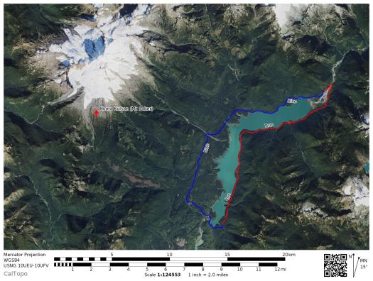
Yesterday I completed a human-powered circumnavigation of Baker Lake, which is just a fancy way of saying I ran down the east side of the lake and then biked back to my car along the west side. It was a fun way to avoid an out-and-back on a trail that I already know pretty well. The entire trail and the road were both snow-free, as were all the backcountry campsites! (Nothing like a snowy winter to make you supremely grateful for snow-free lowlands in the spring!)
Bike stash:
I started my day by driving to the north trailhead (directions here) and stashing my bike behind a large mound of dirt/vegetation on the side of the road, approx 1/4 mile before the trailhead. The entire road is lined with dense forest = lots of great places to hide a bike! I locked mine to a small tree, removed all scented items (to discourage critters), and nobody bothered it. After stashing my bike, I drove to the southern trailhead (directions here), parked my car, and started up the East Bank Baker Lake trail.

Mt Baker in the morning
Trail Conditions:
The trail along the east side of the lake is single-track, and described well on the WTA website (linked above). If you start from the south, the first 10 miles are in pretty good shape, especially for this time of year – just a few blow-downs and one washout at 5.5 miles that will probably require a lot of effort to fix, but is still passable right now.

Washout at 5.5 miles
The last 5 miles have more blowdowns, including some BIG trees down across the trail at 10.5 miles. As with the washout, the big trees are passable, but removing them will probably require some effort by a trail crew, just due to the size of the trees and the way they are lying.

Big trees down across the trail at 10.5 miles
It’s a really lovely time of year to be out on this trail: there is plenty of water coming down from side creeks, but you can still keep feet dry on all crossings. There are also nice mountain views because the trees haven’t filled out yet – including some great views of Mt Blum. I even got to hear a loon wailing, which is one of my favorite sounds in the world (a bit like a wolf howling).

 Mt Blum from the trail

 Koma Kulshan from the trail


Road conditions:
I started my ride at around 2 pm. If you are riding from north to south, the first 6 miles are on a bumpy gravel road, riddled with potholes. I rode my gravel bike (Specialized Diverge) and was glad for the extra traction, 700 x 38c tubeless tires, and future shock. Could you ride this section on a road bike? Yes, if you are careful and steer around some of the messier spots. But a gravel bike is definitely the preferred choice for this ride.
After riding south for six miles, you hit pavement, which is in relatively good condition. Although there is no established shoulder, on a sunny weekday afternoon traffic was light enough that it wasn’t an issue. I rode in the middle of the road most of the time. When I heard/saw a car I moved right, and they were able to pass me with plenty of room. I was pleasantly surprised with the bike portion of the route. Before I did it, I was just thinking of the bike as a means to an end. I had driven this road several times before and didn’t remember it as particularly scenic. But there are some great views, especially if you stop at the pullouts, and lots of trees and swamps that I never noticed from my car. That’s why we ride bikes, right?!
 Another view of Kulshan from the road
 Roadside views
 More roadside views!
